
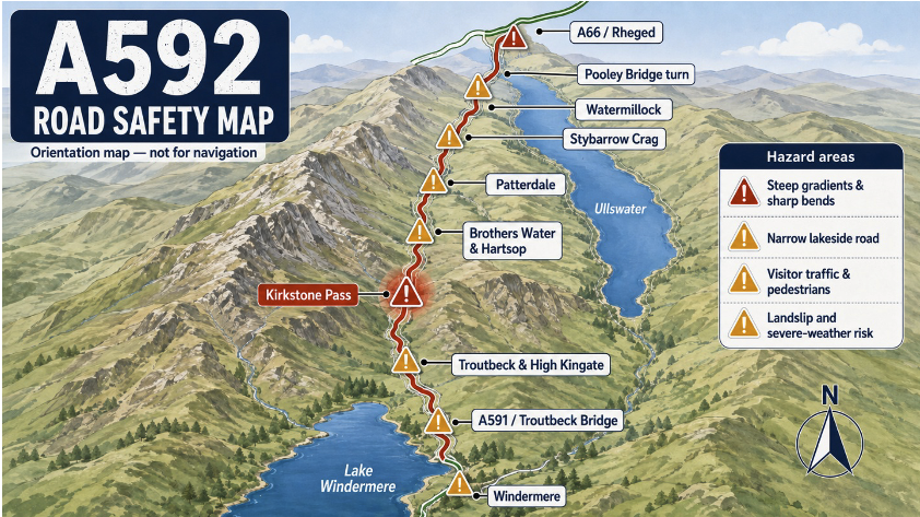
The A592 is one of the Lake District’s most scenic roads, travelling from Windermere towards Troutbeck, Kirkstone Pass, Patterdale and Ullswater before reaching the A66 near Rheged. Its mountain views and lakeside scenery attract large numbers of visitors, but the route can be demanding. Steep gradients, sharp bends, narrow sections and rapidly changing weather leave little room for error.
A recognised high-risk route
The 24-mile section between Windermere and the A66 was selected for improvements through the Government’s Safer Roads Fund. Work has included resurfacing, clearer road markings, improved bend signs, verge markers, drainage repairs and improved roadside barriers. These measures make hazards easier to identify, but drivers must still select a speed suitable for the road, visibility and weather.
Windermere and Bowness
Around Windermere and Bowness, the A592 carries local traffic alongside visitors, buses, coaches, cyclists and pedestrians. Congestion can build quickly during weekends and holidays.
Drivers should expect:
• Vehicles slowing to find hotels or car parks
• Pedestrians crossing near shops and attractions
• Buses stopping or pulling away
• Queues at junctions
• Unfamiliar drivers making late turns
• Cyclists travelling beside slow-moving traffic
Maintain a steady speed and avoid sudden lane or direction changes. If a turning is missed, continue safely and find another route rather than braking sharply.
The A591 and Troutbeck Bridge area
Traffic becomes particularly busy around the connections with the A591 and the roads serving Troutbeck Bridge. Vehicles may be joining from different directions or slowing for local entrances. Visitors following sat-nav instructions can hesitate or change direction unexpectedly. Choose the correct route early, leave a generous following distance and avoid overtaking near junctions.
Troutbeck and High Kingate
North of Windermere, the route becomes narrower and more rural. Bends, walls, property entrances and changes in gradient can restrict the view ahead. This area has been subject to landslips after heavy rain, which have been addressed in most parts through road improvements.
Kirkstone Pass
Kirkstone Pass is the most demanding part of the route. The road climbs steeply to one of the Lake District’s highest passes, with tight bends, exposed sections and significant drops beside the carriageway. Conditions can change quickly. Drivers may leave Windermere in sunshine and encounter fog, heavy rain, ice or strong winds higher up.
Before climbing the pass:
• Check the weather and road conditions
• Use a suitable gear before steep sections
• Reduce speed before bends
• Stay well within your lane
• Avoid overtaking without a complete view
• Allow extra room for cyclists and motorcycles
• Expect sheep or other livestock near the road
Drivers descending the pass should select a lower gear rather than relying continuously on the brakes. Prolonged braking can cause overheating and reduce effectiveness.
Brothers Water and Hartsop
North of Kirkstone Pass, the A592 descends towards Brothers Water and Hartsop. The road remains narrow and winding, with walls, bridges and limited forward visibility. Walkers may cross between parking areas and paths, while vehicles can slow suddenly when searching for a parking place. Never stop on a bend or where the vehicle would obstruct traffic.
Surface water, fallen stones and loose material may also appear after bad weather.
Patterdale
At Patterdale, the A592 passes through a small community popular with walkers. Pedestrians, parked vehicles, buses and property entrances bring additional hazards. Drivers should reduce speed before entering the village and watch for people stepping into the road from behind parked vehicles. Patience is particularly important during busy visitor periods.
Glenridding
Glenridding is another major concern area. Traffic serving Ullswater, local accommodation and walking routes can create queues and frequent turning movements.
Drivers may encounter:
• Pedestrians crossing near shops and parking areas
• Cars stopping to find directions
• Buses and coaches needing extra space
• Vehicles entering or leaving car parks
• Cyclists travelling through the village
• Congestion during holidays and events
Travel slowly enough to stop if a pedestrian or vehicle appears unexpectedly.
Stybarrow Crag and the Ullswater shore
Beyond Glenridding, the A592 runs close to Ullswater and passes beneath steep slopes around Stybarrow Crag. Falling rocks, water runoff and debris can affect the road, especially after storms or prolonged rain. The route contains repeated bends where the lake, rock face or vegetation restricts visibility. Drivers should remain within their lane and be prepared to meet buses, coaches or larger vehicles occupying considerable road space. Do not focus on the scenery while moving. Use a designated parking place if you wish to enjoy the view.
Watermillock and lakeside junctions
Further north, the A592 continues through Watermillock and past several minor roads, accommodation entrances and visitor locations. Vehicles may slow sharply to turn into an entrance that is difficult to see. Agricultural machinery, cyclists and walkers are also common. Leave enough space behind the vehicle ahead and avoid overtaking near bends, crests or junctions.
The Pooley Bridge turn
Traffic levels can increase around the junctions serving Pooley Bridge, particularly during weekends and holiday periods. Vehicles may queue or turn across the path of approaching traffic. Approach at a controlled speed and look carefully for motorcycles and bicycles, which may be hidden behind larger vehicles.
The A66 junction near Rheged
The northern end of the safer-roads section reaches the A66 near Rheged. After miles of narrow and winding road, drivers must adjust to a much faster and busier traffic environment. Watch for queues, select the correct lane early and judge the speed of approaching vehicles carefully. Don’t let pressure from traffic behind force you into an unsafe gap.
Main areas requiring extra care
The principal concern points are:
• Windermere and Bowness
• The A591 and Troutbeck Bridge area
• Troutbeck and High Kingate
• The climb and descent of Kirkstone Pass
• Brothers Water and Hartsop
• Patterdale
• Glenridding
• Stybarrow Crag
• The narrow lakeside section beside Ullswater
• Watermillock and local junctions
• The Pooley Bridge turn
• The A66 junction near Rheged
A beautiful road that must be respected
The A592 offers some of the finest scenery in the Lake District, but it is not a road to rush. A clear stretch can quickly become a sharp bend, steep descent or busy visitor area. Slow down before bends, leave extra space and expect conditions to change with little warning. On Kirkstone Pass and beside Ullswater, a calm and patient journey is the safest way to enjoy this remarkable route