The Cat and Fiddle road, the A537, runs between Buxton in Derbyshire and Macclesfield, Cheshire. It’s named after the Cat & Fiddle Inn public house on its summit. It’s a fast yet highly challenging rural road, which has become well noted for many reasons. While it’s a real driver’s (and bikers’) road, it’s also lethal if you fail to drive or ride defensively.

The profile of collisions and the sting in the cat’s tail….
Geometry & environment. The descent to Macclesfield strings together many tight, often blind bends with steep drop‑offs and dry‑stone walls close to the carriageway; winter brings fog, snow and ice. These features amplify consequences when riders/drivers misjudge entry speed or line.
Behavioural factors dominate. Local safety analyses point to loss‑of‑control on bends and excess speed (either above the limit or too fast for conditions) as frequent factors in recorded collisions.
Motorcycles are over‑represented. Across the historic high‑risk years, most KSI (killed or seriously injured) involved motorcyclists, which is why countermeasures and enforcement were tailored to two‑wheelers.
Here is a look at the parts of this road which have seen the most serious collisions (ksi) over the last 10 years:
Location – On the approach to Ankers Knowl Lane
What3Words – ///irritable.pricing.blueberry
This part of the Cat and Fiddle road has a number of recorded serious collisions. But why? There is a junction on the right, combined with a sweeping turn to the left. A stone wall, lethal for bikers, is evident to the left, too. Just before this corner, (photo looks east), there is a steep decline, which may encourage some to speed up a little too much before this corner. Junctions are always notorious for collisions.
Tips – If you’re heading east, be aware of the extra speed which may creep on when descending the hill towards this junction. Most of the collisions here appear to involve traffic heading east. Use your elevated position when descending to look far ahead, and if possible, into the upcoming junction on the right for any vehicle that may be waiting there or approaching the junction. Looking ahead means you can plan more effectively.
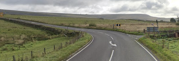
Location – Under a mile east after Ankers Knowl Lane junction
What3Words – ///league.saloons.zinc
Heading east, under a mile from the above photo, is a corner that has, in recent years, had a fatality and a number of collisions. This is a fast, long right bend. While it’s relatively open and you can see into and around the open corner, there is a stone wall on the offside – again, lethal for bikers. On the nearside, there is a small drop from the road. Due to its open nature, it can cause drivers and bikers to become too overconfident. Note the skid marks in the photo.

Tips – Look for clues, we can see skid marks on the road, meaning at least one driver has entered too fast, albeit it looks like a large commercial vehicle and not a car. Be aware that it may look like a fun open corner, but it can catch you, and other drivers/bikers out. There is a junction on the left just before the corner – be aware of any traffic merging. The chevron markers with a yellow background act as a warning and give a good indication that it’s a challenging corner. Take the time to look through the corner, casting your eyes over the greenery on the offside to see and plan for any approaching traffic coming in the opposite direction.
Location – Less than a mile eastbound from the above photo, where the road runs above Tor Brook.
What3Words – ///blotchy.airbase.outwards
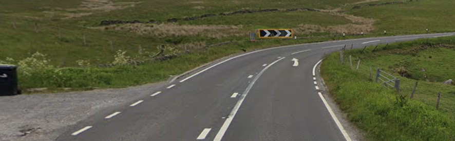
This is almost identical to the photo above. However, it has a higher collision rate. It features a junction on the left and includes additional traffic calming measures, including a solid white line for oncoming motorists heading west. Just after this corner, heading east, there is a very short, solid white line, which strongly suggests an attempt to calm traffic exiting the corner.
Tips – Much the same as the tips given above, but pay particular attention to the road markings – they are trying to tell you something.
Location – At the Cat & Fiddle
What3Words – ///haunt.fluffed.compiled
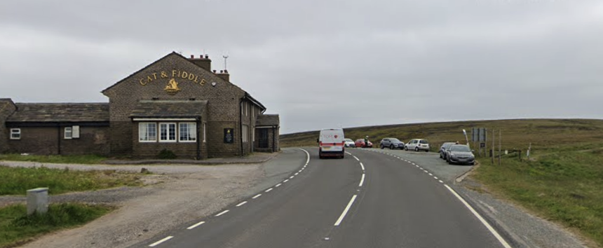
A number of collisions have been recorded at the summit where the Cat & Fiddle pub is. With a junction (and pub!) to the left, parked traffic on the right, and a crest that bears off to the left, it will always mean an increased collision rate.
Tips – Be prepared for motorists exiting the pub, especially so as the entrance and exit are just over the crest in the road on the corner. If safe, heading eastbound, move to the centre of the road for improved visibility of the corner. Watch for pedestrians crossing the road to access parked vehicles on the right, especially if they have been drinking.
Historically, the Cat and Fiddle, one of Britain’s most notorious collision hotspots, especially for motorcyclists, saw dozens of fatal/serious crashes in the late‑2000s/early‑2010s. A package of engineering + average‑speed enforcement has since driven around a 77% KSI reduction, with councils now upgrading the system to keep risk low. Serious crashes still occur, but the trend is markedly improved.
Remember –
Hold the 50 limit. The route is enforced end‑to‑end; the system measures your average speed between cameras (including for motorcycles).
Read the road early. Late braking into blind, downhill bends is a common precursor to loss‑of‑control collisions.
Expect fast‑changing weather and livestock. Visibility and grip can change quickly across the moor.
Why are Rural Roads So Deadly?
It’s not just the Cat and Fiddle road. There are many rural roads which combine a lethal combination of factors. Here is a brief insight to these:
Higher Speeds and Less Regulation:
One of the main reasons rural roads are so dangerous is the higher speeds at which vehicles travel. With fewer traffic signals, fewer 30/40 speed limits, fewer stop signs, and fewer police around, drivers are more likely to speed. Excessive speeds increase the distance it takes to respond to hazards, making it harder to avoid collisions with obstacles, other vehicles, or animals crossing the road.
Poor Road Conditions:
Many roads in the UK have deteriorated in recent years, with potholes being the main offender. This is true on both urban and rural roads. But on rural roads, this problem tends to be far worse. A mix of potholes, narrow lanes, sharp curves, worn, polished road surfaces, and inadequate signage all increase the risk for drivers. These conditions increase the likelihood of losing control, especially for drivers unfamiliar with the area or driving too fast. Additionally, weather-related hazards such as ice, fog, and flooding are more common on rural roads.
Visibility:
Unlike urban roads, rural roads often lack proper street lighting, making night driving particularly hazardous. Blind curves, overgrown hedges, and sudden elevation changes can obstruct visibility, making it difficult for drivers to spot potential dangers in time. Dazzle from oncoming vehicles at night is also another hazard to deal with.
Increased Response Times:
In the unfortunate event of a collision, emergency response times on rural roads tend to be much longer due to the remoteness of these locations. This delay in medical attention significantly increases the risk of fatalities and severe injuries. Also, it may not always be easy to spot if someone has come off the road, if they have ended up in the undergrowth or down a verge, for example.
Wildlife Risks:
Rural areas are home to a variety of wildlife, and animals frequently cross roads unexpectedly. Collisions with large animals such as deer can cause serious accidents. Smaller animals, while they may not pose as dangerous a risk as deer, can startle a driver, which can lead to serious issues.
Other Risks:
There are endless risks on rural roads, while some are outlined above, the list goes on, here are a few more to consider:
* Mud on the road
* Farm machinery
* Cattle
* Drink drivers
* Wannabe rally drivers
* Blind entrances
* Fallen tress
* Horse riders
* Cyclists
* Walkers
When you’re on a rural road, you don’t have a co-driver, so you need to be trying your best to read the road ahead. Using the System of Car Control will help.